


KJLN - Joplin Rgnl
Located in Joplin, United States
ICAO - JLN, IATA - JLN
Data provided by AirmateGeneral information
Coordinates: N37°9'11" W94°29'56"
Elevation is 977 feet MSL.
Magnetic variation is 04° East View others Airports in Missouri
Operational data
Special qualification required
Current time UTC:
Current local time:
Weather
METAR: KJLN 071553Z 23011KT 10SM FEW018 22/16 A2962 RMK AO2 SLP020 T02220156
TAF: KJLN 071339Z 0714/0812 22013KT P6SM BKN008 FM071700 23013KT P6SM SKC FM080300 17010KT P6SM SKC FM080800 17010KT P6SM FEW250 WS020/20045KT
Communications frequencies: [VIEW]
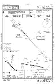
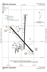
Runways:
| RWY identifier | QFU | Length (ft) | Width (ft) | Surface | LDA (ft) |
| 13 | 138° | 6501 | 150 | ASPH | 5813 |
| 31 | 318° | 6501 | 150 | ASPH | 5813 |
| 18 | 182° | 6502 | 100 | CONC | 6499 |
| 36 | 2° | 6502 | 100 | CONC | 6499 |
Airport contact information
Address: Joplin United States

