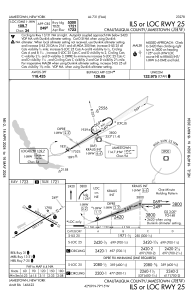
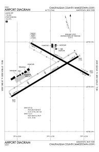


KJHW - Chautauqua County/Jamestown
Located in Jamestown, United States
ICAO - JHW, IATA - JHW
Data provided by AirmateGeneral information
Coordinates: N42°9'12" W79°15'29"
Elevation is 1723 feet MSL.
Magnetic variation is -10° East View others Airports in New York
Operational data
Special qualification required
Current time UTC:
Current local time:
Weather
METAR: KJHW 300256Z AUTO 19006KT 10SM CLR 20/12 A2992 RMK AO2 SLP125 T02000117 58000
TAF: KJHW 292333Z 3000/3024 19006KT P6SM SCT120 FM300700 24004KT P6SM BKN080 FM301000 20004KT P6SM BKN015 FM301100 21004KT P6SM OVC007 FM301400 25006KT 4SM SHRA BR OVC012 FM301800 26006KT 6SM BR VCSH BKN012 FM302100 27007KT P6SM BKN030
Communications frequencies: [VIEW]
Runways:
| RWY identifier | QFU | Length (ft) | Width (ft) | Surface | LDA (ft) |
| 07 | 59° | 5300 | 100 | ASPH | 5300 |
| 25 | 239° | 5300 | 100 | ASPH | 5300 |
| 13 | 119° | 4499 | 100 | ASPH | 4499 |
| 31 | 299° | 4499 | 100 | ASPH | 4499 |
Airport contact information
Address: Jamestown United States
Other aviation service providers
Flight schools

Jamestown Aviation Company, Llc
Jamestown Aviation Company, Llc
lnalbone@jamestownaviation.com+1(716)665-4800