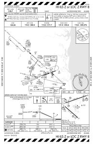
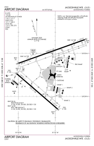


KJAX - Jacksonville Intl
Located in Jacksonville, United States
ICAO - JAX, IATA - JAX
Data provided by AirmateGeneral information
Coordinates: N30°29'39" W81°41'16"
Elevation is 29 feet MSL.
Magnetic variation is -06° East View others Airports in Florida
Operational data
Special qualification required
Current time UTC:
Current local time:
Weather
METAR: KJAX 031056Z 00000KT 7SM FEW003 FEW090 SCT250 18/17 A3000 RMK AO2 SLP161 VIS W 1 T01780167
TAF: KJAX 031120Z 0312/0412 00000KT 6SM BR SCT003 FM031300 12005KT P6SM FEW030 FM031900 11011KT P6SM SCT040 BKN250 FM040100 VRB04KT P6SM BKN250
Communications frequencies: [VIEW]
Runways:
| RWY identifier | QFU | Length (ft) | Width (ft) | Surface | LDA (ft) |
| 08 | 71° | 10000 | 150 | CONC | |
| 26 | 251° | 10000 | 150 | CONC | |
| 14 | 131° | 7701 | 150 | CONC | |
| 32 | 311° | 7701 | 150 | CONC |
Airport contact information
Address: Jacksonville United States