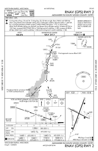
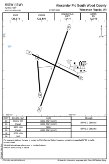


KISW - Alexander Fld South Wood County
Located in Wisconsin Rapids, United States
ICAO - ISW, IATA - ISW
Data provided by AirmateGeneral information
Coordinates: N44°21'37" W89°50'21"
Elevation is 1021 feet MSL.
Magnetic variation is -01° East View others Airports in Wisconsin
Operational data
Special qualification required
Current time UTC:
Current local time:
Weather
METAR: KISW 290209Z AUTO 07008KT 4SM BR SCT006 SCT011 OVC016 06/06 A2988 RMK AO2 RAE0158 P0000 T00610056
Communications frequencies: [VIEW]
Runways:
| RWY identifier | QFU | Length (ft) | Width (ft) | Surface | LDA (ft) |
| 02 | 20° | 5500 | 100 | ASPH | |
| 20 | 200° | 5500 | 100 | ASPH | |
| 12 | 116° | 3470 | 60 | ASPH | |
| 30 | 296° | 3470 | 60 | ASPH | |
| 18 | 176° | 2072 | 50 | GRASS | |
| 36 | 356° | 2072 | 50 | GRASS |
Airport contact information
Address: Wisconsin Rapids United States
