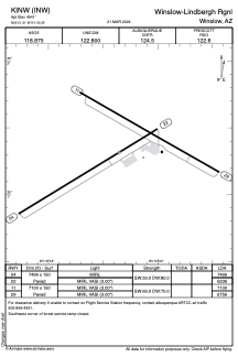


KINW - Winslow-Lindbergh Rgnl
Located in Winslow, United States
ICAO - INW, IATA - INW
Data provided by AirmateGeneral information
Coordinates: N35°1'19" W110°43'21"
Elevation is 4941 feet MSL.
Magnetic variation is 14° East View others Airports in Arizona
Operational data
Special qualification required
Current time UTC:
Current local time:
Weather
METAR: KINW 031356Z AUTO 22009KT 10SM CLR 15/M01 A2997 RMK AO2 SLP089 T01501006
TAF: KINW 031120Z 0312/0412 18005KT P6SM SKC FM031900 24012G20KT P6SM FEW120 FM040200 22009KT P6SM BKN120 FM040900 19005KT P6SM FEW120
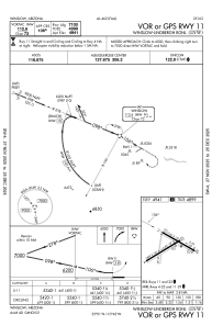
Communications frequencies: [VIEW]
Runways:
| RWY identifier | QFU | Length (ft) | Width (ft) | Surface | LDA (ft) |
| 04 | 59° | 7499 | 150 | ASPH | 7499 |
| 22 | 239° | 7499 | 150 | ASPH | 6236 |
| 11 | 120° | 7100 | 150 | ASPH | 7100 |
| 29 | 300° | 7100 | 150 | ASPH | 6756 |
Airport contact information
Address: Winslow United States