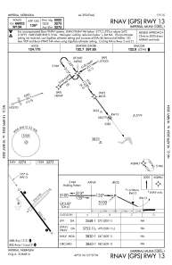
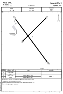


KIML - Imperial Muni
Located in Imperial, United States
ICAO - IML, IATA - IML
Data provided by AirmateGeneral information
Coordinates: N40°30'37" W101°37'13"
Elevation is 3276 feet MSL.
Magnetic variation is 09° East View others Airports in Nebraska
Operational data
Special qualification required
Current time UTC:
Current local time:
Weather
METAR: KIML 292153Z AUTO 23009G18KT 10SM FEW095 23/M01 A2982 RMK AO2 PK WND 26031/2121 SLP090 T02281006
Communications frequencies: [VIEW]
Runways:
| RWY identifier | QFU | Length (ft) | Width (ft) | Surface | LDA (ft) |
| 03 | 46° | 2756 | 280 | GRASS | |
| 21 | 226° | 2756 | 280 | GRASS | |
| 13 | 144° | 5022 | 100 | CONC | |
| 31 | 324° | 5022 | 100 | CONC |
Airport contact information
Address: Imperial United States