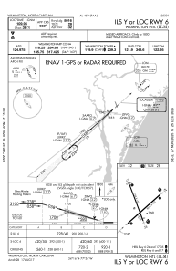
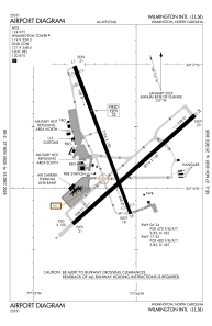


KILM - Wilmington Intl
Located in Wilmington, United States
ICAO - ILM, IATA - ILM
Data provided by AirmateGeneral information
Coordinates: N34°16'16" W77°54'10"
Elevation is 31 feet MSL.
Magnetic variation is -10° East View others Airports in North Carolina
Operational data
Special qualification required
Current time UTC:
Current local time:
Weather
METAR: KILM 021205Z 00000KT 7SM FEW003 SCT006 20/19 A3002 RMK AO2 T02000194
TAF: KILM 021142Z 0212/0312 04003KT 5SM BR BKN003 FM021230 08004KT P6SM SKC FM021700 14008KT P6SM SKC FM022300 00000KT P6SM SKC FM030900 00000KT 1SM BR BKN005
Communications frequencies: [VIEW]
Runways:
| RWY identifier | QFU | Length (ft) | Width (ft) | Surface | LDA (ft) |
| 06 | 48° | 8016 | 150 | ASPH | 8016 |
| 24 | 228° | 8016 | 150 | ASPH | 8016 |
| 17 | 159° | 7754 | 150 | ASPH | 6604 |
| 35 | 339° | 7754 | 150 | ASPH | 7204 |
Airport contact information
Address: Wilmington United States