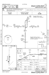
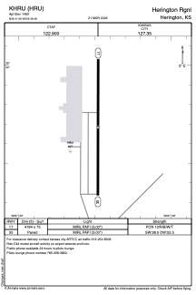


KHRU - Herington Rgnl
Located in Herington, United States
ICAO - HRU, IATA -
Data provided by AirmateGeneral information
Coordinates: N38°41'41" W96°48'29"
Elevation is 1480 feet MSL.
Magnetic variation is 06° East View others Airports in Kansas
Operational data
Special qualification required
Current time UTC:
Current local time:
Weather at : KFRI - Marshall Aaf ( 40 km )
METAR: KFRI 071155Z AUTO 24003KT 10SM CLR 08/07 A2956 RMK AO2 SLP005 T00790071 10138 20075 52020 PNO $
TAF: TAF KFRI 071200Z 0712/0818 VRB06KT 9999 SKC QNH2956INS BECMG 0714/0715 25010G15KT 9999 FEW200 QNH2957INS BECMG 0715/0716 26015G25KT 9999 FEW200 QNH2959INS BECMG 0723/0724 22010G15KT 9999 BKN150 QNH2950INS BECMG 0805/0806 15006KT 8000 -SHRA BKN150 QNH2949INS BECMG 0808/0809 11006KT 9999 NSW FEW100 QNH2953INS TX24/0721Z TN08/0712Z
Communications frequencies: [VIEW]
Runways:
| RWY identifier | QFU | Length (ft) | Width (ft) | Surface | LDA (ft) |
| 17 | 180° | 4184 | 75 | CONC | |
| 35 | 0° | 4184 | 75 | CONC |
Airport contact information
Address: Herington United States