


KHOU - William P Hobby
Located in Houston, United States
ICAO - HOU, IATA - HOU
Data provided by AirmateGeneral information
Coordinates: N29°38'45" W95°16'38"
Elevation is 46 feet MSL.
Magnetic variation is 03° East View others Airports in Texas
Operational data
Special qualification required
Current time UTC:
Current local time:
Weather
METAR: KHOU 011453Z 13013KT 10SM SCT016 BKN023 OVC250 26/22 A2991 RMK AO2 SLP132 T02610222 51009
TAF: KHOU 011454Z 0115/0212 13007KT P6SM FEW015 BKN025 BKN050 FM012000 13010G20KT P6SM VCSH BKN030 FM020200 13010KT P6SM BKN015 FM020900 15013KT P6SM VCTS OVC006CB
Communications frequencies: [VIEW]
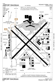
Runways:
| RWY identifier | QFU | Length (ft) | Width (ft) | Surface | LDA (ft) |
| 04 | 44° | 7602 | 150 | CONC | 7602 |
| 22 | 224° | 7602 | 150 | CONC | 7602 |
| 13L | 134° | 5148 | 100 | CONC | 5148 |
| 31R | 314° | 5148 | 100 | CONC | 5148 |
| 13R | 134° | 7602 | 150 | ASPH | 6568 |
| 31L | 314° | 7602 | 150 | ASPH | 7602 |
Airport contact information
Address: Houston United States
