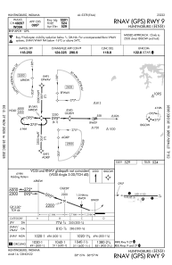
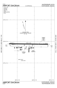


KHNB - Huntingburg
Situé à Huntingburg, United States
ICAO - HNB, IATA - HNB
Données fournies par AirmateInformation générale
Coordonnées: N38°14'56" W86°57'10"
Élévation : 529 feet MSL.
Variation magnétique : -04° East Voir autres Aéroports à Indiana
Données opérationnelles
Special qualification required
Heure actuelle UTC:
Heure actuelle locale:
Météo
METAR: KHNB 151956Z AUTO 30007KT OVC018 21/18 A2976 RMK AO2 SLP076 T02110178 PWINO PNO $
TAF: KHNB 151731Z 1518/1618 34005KT P6SM VCTS BKN015CB FM152100 34007KT P6SM VCTS OVC025CB FM160000 34004KT P6SM SCT050 FM160900 00000KT 4SM BR OVC015 TEMPO 1609/1612 1SM BR OVC004 FM161400 20005KT P6SM SCT050
Fréquences de communication: [VIEW]
Pistes:
| Identifiant RWY | QFU | Longueur (ft) | Largeur (ft) | Surface | LDA (ft) |
| 09 | 91° | 5501 | 100 | ASPH | |
| 27 | 271° | 5501 | 100 | ASPH |
Coordonnées de l'aéroport
Adresse: Huntingburg United States
