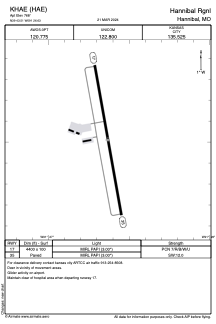


KHAE - Hannibal Rgnl
Located in Hannibal, United States
ICAO - HAE, IATA -
Data provided by AirmateGeneral information
Coordinates: N39°43'31" W91°26'38"
Elevation is 768 feet MSL.
Magnetic variation is 00° East View others Airports in Missouri
Operational data
Special qualification required
Current time UTC:
Current local time:
Weather
METAR: KHAE 070755Z AUTO 16010G17KT 10SM SCT075 BKN085 OVC110 22/17 A2956 RMK AO2 LTG DSNT W AND NW
Communications frequencies: [VIEW]
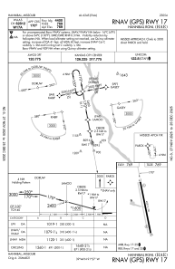
Runways:
| RWY identifier | QFU | Length (ft) | Width (ft) | Surface | LDA (ft) |
| 17 | 170° | 4400 | 100 | CONC | |
| 35 | 350° | 4400 | 100 | CONC |
Airport contact information
Address: Hannibal United States
