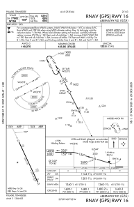
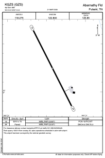


KGZS - Abernathy Fld
Located in Pulaski, United States
ICAO - GZS, IATA -
Data provided by AirmateGeneral information
Coordinates: N35°9'15" W87°3'25"
Elevation is 688 feet MSL.
Magnetic variation is -02° East View others Airports in Tennessee
Operational data
Special qualification required
Current time UTC:
Current local time:
Weather
METAR: KGZS 301135Z AUTO 00000KT 10SM SCT039 SCT055 BKN065 16/16 A3000 RMK A01
Communications frequencies: [VIEW]
Runways:
| RWY identifier | QFU | Length (ft) | Width (ft) | Surface | LDA (ft) |
| 16 | 153° | 5310 | 75 | ASPH | |
| 34 | 333° | 5310 | 75 | ASPH |
Airport contact information
Address: Pulaski United States