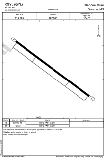


KGYL - Glencoe Muni
Located in Glencoe, United States
ICAO - GYL, IATA -
Data provided by AirmateGeneral information
Coordinates: N44°45'22" W94°4'53"
Elevation is 992 feet MSL.
Magnetic variation is 03° East View others Airports in Minnesota
Operational data
Special qualification required
Current time UTC:
Current local time:
Weather
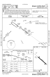
METAR: KGYL 061855Z AUTO 13021G27KT 10SM CLR 22/07 A2980 RMK AO2 T02230070
Communications frequencies: [VIEW]
Runways:
| RWY identifier | QFU | Length (ft) | Width (ft) | Surface | LDA (ft) |
| 13 | 127° | 3300 | 75 | ASPH | |
| 31 | 307° | 3300 | 75 | ASPH |
Airport contact information
Address: Glencoe United States