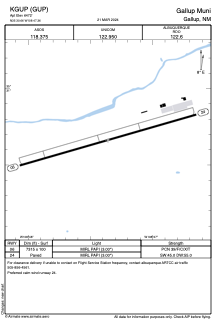


KGUP - Gallup Muni
Located in Gallup, United States
ICAO - GUP, IATA - GUP
Data provided by AirmateGeneral information
Coordinates: N35°30'40" W108°47'22"
Elevation is 6472 feet MSL.
Magnetic variation is 12° East View others Airports in New Mexico
Operational data
Special qualification required
Current time UTC:
Current local time:
Weather
METAR: KGUP 290553Z AUTO 05003KT 10SM CLR 01/M01 A3010 RMK AO2 SLP153 T00111006 10144 20011 51009 $
TAF: KGUP 290526Z 2906/3006 VRB03KT P6SM SKC FM291700 24011G19KT P6SM SKC FM300200 22006KT P6SM SKC
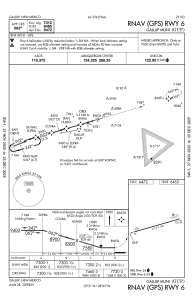
Communications frequencies: [VIEW]
Runways:
| RWY identifier | QFU | Length (ft) | Width (ft) | Surface | LDA (ft) |
| 06 | 74° | 7315 | 100 | ASPH | |
| 24 | 254° | 7315 | 100 | ASPH |
Airport contact information
Address: Gallup United States