


KGTB - Wheeler-Sack Aaf
Located in Fort Drum, United States
ICAO - GTB, IATA -
Data provided by AirmateGeneral information
Coordinates: N44°3'20" W75°43'12"
Elevation is 689 feet MSL.
Magnetic variation is -13° East View others Airports in New York
Operational data
Special qualification required
Current time UTC:
Current local time:
Weather
METAR: KGTB 300755Z 06011KT 10SM CLR 10/07 A2982 RMK AO2A SLP099 T00950068
TAF: TAF AMD KGTB 300419Z 3004/0107 08010KT 9999 FEW015 BKN020 OVC030 QNH2986INS TEMPO 3004/3006 8000 -SHRA VCTS OVC015CB BECMG 3020/3021 04010KT 8000 -SHRA OVC015 QNH2984INS BECMG 3022/3023 VRB06KT 9999 NSW OVC020 QNH2984INS TX14/3014Z TN06/0101Z
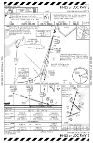
Communications frequencies: [VIEW]
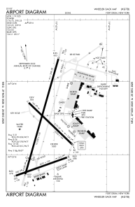
Runways:
| RWY identifier | QFU | Length (ft) | Width (ft) | Surface | LDA (ft) |
| 03 | 0° | 10000 | 150 | CONC | |
| 21 | 0° | 10000 | 150 | CONC | |
| 08 | 0° | 4501 | 150 | OTHER | |
| 26 | 0° | 4501 | 150 | OTHER | |
| 15 | 0° | 5002 | 144 | CONC | |
| 33 | 0° | 5002 | 144 | CONC |
Airport contact information
Address: Fort Drum United States