


KGPI - Glacier Park Intl
Located in Kalispell, United States
ICAO - GPI, IATA - FCA
Data provided by AirmateGeneral information
Coordinates: N48°18'38" W114°15'22"
Elevation is 2976 feet MSL.
Magnetic variation is 15° East View others Airports in Montana
Operational data
Special qualification required
Current time UTC:
Current local time:
Weather
METAR: KGPI 290755Z AUTO 17009KT 10SM CLR 07/01 A2985 RMK AO2 SLP110 T00670011
TAF: KGPI 290528Z 2906/3006 20008KT P6SM VCSH OVC060 FM291400 20010G20KT P6SM -SHRA OVC050 FM300200 18008KT P6SM VCSH OVC050
Communications frequencies: [VIEW]
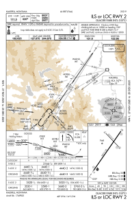
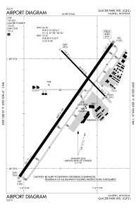
Runways:
| RWY identifier | QFU | Length (ft) | Width (ft) | Surface | LDA (ft) |
| 02 | 35° | 9007 | 150 | ASPH | 9007 |
| 20 | 215° | 9007 | 150 | ASPH | 9007 |
| 12 | 136° | 3510 | 75 | ASPH | 3510 |
| 30 | 316° | 3510 | 75 | ASPH | 3510 |
Airport contact information
Address: Kalispell United States
