


KGEZ - Shelbyville Muni
Located in Shelbyville, United States
ICAO - GEZ, IATA -
Data provided by AirmateGeneral information
Coordinates: N39°34'59" W85°48'17"
Elevation is 802 feet MSL.
Magnetic variation is -04° East View others Airports in Indiana
Operational data
Special qualification required
Current time UTC:
Current local time:
Weather
METAR: KGEZ 030753Z AUTO 23017G24KT 10SM FEW065 FEW080 OVC100 23/16 A2991 RMK AO2 RAB32E43 SLP122 P0000 T02280156
Communications frequencies: [VIEW]
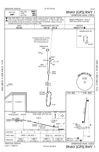
Runways:
| RWY identifier | QFU | Length (ft) | Width (ft) | Surface | LDA (ft) |
| 01 | 5° | 5000 | 100 | ASPH | |
| 19 | 185° | 5000 | 100 | ASPH | |
| 09 | 92° | 2671 | 190 | GRASS | |
| 27 | 272° | 2671 | 190 | GRASS |
Airport contact information
Address: Shelbyville United States