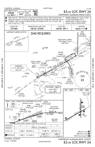
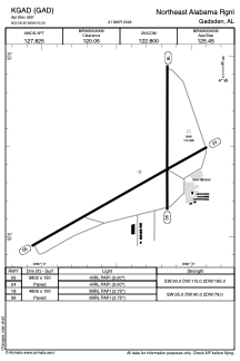


KGAD - Northeast Alabama Rgnl
Located in Gadsden, United States
ICAO - GAD, IATA -
Data provided by AirmateGeneral information
Coordinates: N33°58'22" W86°5'21"
Elevation is 569 feet MSL.
Magnetic variation is -03° East View others Airports in Alabama
Operational data
Special qualification required
Current time UTC:
Current local time:
Weather
METAR: KGAD 282056Z AUTO VRB05KT 10SM CLR 26/13 A3016 RMK AO2 SLP212 T02610133 56012 $
Communications frequencies: [VIEW]
Runways:
| RWY identifier | QFU | Length (ft) | Width (ft) | Surface | LDA (ft) |
| 06 | 61° | 6802 | 150 | ASPH | |
| 24 | 241° | 6802 | 150 | ASPH | |
| 18 | 180° | 4806 | 100 | ASPH | |
| 36 | 0° | 4806 | 100 | ASPH |
Airport contact information
Address: Gadsden United States
