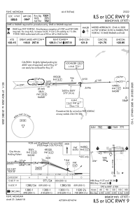
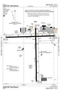


KFNT - Bishop Intl
Located in Flint, United States
ICAO - FNT, IATA - FNT
Data provided by AirmateGeneral information
Coordinates: N42°57'56" W83°44'41"
Elevation is 782 feet MSL.
Magnetic variation is -06° East View others Airports in Michigan
Operational data
Special qualification required
Current time UTC:
Current local time:
Weather
METAR: KFNT 042353Z 17006KT 10SM OVC028 21/17 A2990 RMK AO2 SLP123 60000 T02110167 10239 20211 55007
TAF: KFNT 042328Z 0500/0524 18005KT P6SM BKN025 OVC040 FM050400 18005KT 4SM BR SCT008 BKN015 OVC025 FM050800 20005KT 2SM BR OVC008 TEMPO 0508/0511 3SM -SHRA BR FM051100 32010KT P6SM BKN015 OVC025 FM051400 36013KT P6SM BKN025 OVC040 FM051900 03010KT P6SM SCT045
Communications frequencies: [VIEW]
Runways:
| RWY identifier | QFU | Length (ft) | Width (ft) | Surface | LDA (ft) |
| 09 | 88° | 7201 | 150 | ASPH | 7201 |
| 27 | 268° | 7201 | 150 | ASPH | 7201 |
| 18 | 179° | 7852 | 150 | ASPH | 7650 |
| 36 | 359° | 7852 | 150 | ASPH | 7652 |
Airport contact information
Address: Flint United States
