


KFFO - Wright-Patterson Afb
Located in Dayton, United States
ICAO - FFO, IATA - FFO
Data provided by AirmateGeneral information
Coordinates: N39°49'33" W84°2'46"
Elevation is 823 feet MSL.
Magnetic variation is -04° East View others Airports in Ohio
Operational data
Special qualification required
Current time UTC:
Current local time:
Weather
METAR: KFFO 290555Z AUTO 22006KT 10SM CLR 19/14 A3001 RMK AO2 SLP160 T01930135 10256 20191 55000
TAF: TAF KFFO 290300Z 2903/3009 18009KT 9999 FEW040 510103 QNH2998INS BECMG 2913/2914 21012KT 9999 SCT040 BKN055 510033 QNH2983INS TEMPO 2914/2923 18020G25KT 520053 WND 120V250 BECMG 3003/3004 20009KT 4800 -RA BKN015 OVC030 QNH2980INS TEMPO 3005/3009 19012G18KT 3200 RA BKN009 OVC015 TX28/2919Z TN18/2911Z
Communications frequencies: [VIEW]
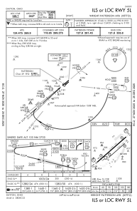
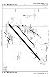
Runways:
| RWY identifier | QFU | Length (ft) | Width (ft) | Surface | LDA (ft) |
| 05R | 0° | 7000 | 150 | ASPH | |
| 23L | 0° | 7000 | 150 | ASPH | |
| 05L | 0° | 12600 | 300 | OTHER | |
| 23R | 0° | 12600 | 300 | OTHER |
Airport contact information
Address: Dayton United States