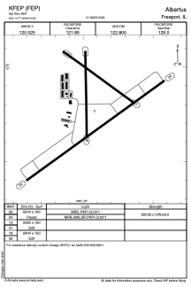


KFEP - Albertus
Located in Freeport, United States
ICAO - FEP, IATA - FEP
Data provided by AirmateGeneral information
Coordinates: N42°14'46" W89°34'55"
Elevation is 859 feet MSL.
Magnetic variation is 00° East View others Airports in Illinois
Operational data
Special qualification required
Current time UTC:
Current local time:
Weather
METAR: KFEP 291015Z AUTO 00000KT BKN070 16/14 A2978 RMK AO2 T01570140
Communications frequencies: [VIEW]
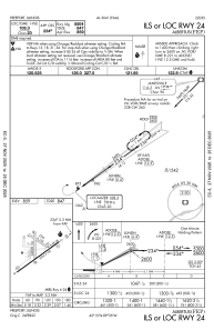
Runways:
| RWY identifier | QFU | Length (ft) | Width (ft) | Surface | LDA (ft) |
| 06 | 54° | 5504 | 100 | ASPH | |
| 24 | 234° | 5504 | 100 | ASPH | |
| 13 | 126° | 2285 | 150 | GRASS | |
| 31 | 306° | 2285 | 150 | GRASS | |
| 18 | 179° | 2404 | 150 | GRASS | |
| 36 | 359° | 2404 | 150 | GRASS |
Airport contact information
Address: Freeport United States