


KFAT - Fresno Yosemite Intl
Located in Fresno, United States
ICAO - FAT, IATA - FAT
Data provided by AirmateGeneral information
Coordinates: N36°46'36" W119°43'8"
Elevation is 335 feet MSL.
Magnetic variation is 13° East View others Airports in California
Operational data
Special qualification required
Current time UTC:
Current local time:
Weather
METAR: KFAT 032353Z 29006KT 10SM FEW050 SCT100 SCT200 28/08 A2980 RMK AO2 SLP086 TCU DSNT N-E-SE T02780083 10289 20211 56021 $
TAF: KFAT 032320Z 0400/0424 30010KT P6SM SKC FM041200 32012KT P6SM SKC FM041900 25010KT P6SM VCSH BKN250
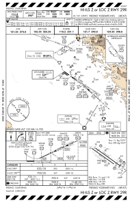
Communications frequencies: [VIEW]
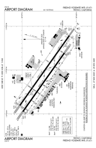
Runways:
| RWY identifier | QFU | Length (ft) | Width (ft) | Surface | LDA (ft) |
| 11L | 125° | 9539 | 150 | ASPH | 9279 |
| 29R | 305° | 9539 | 150 | ASPH | 9227 |
| 11R | 125° | 8008 | 150 | ASPH | 8008 |
| 29L | 305° | 8008 | 150 | ASPH | 8008 |
Airport contact information
Address: Fresno United States

