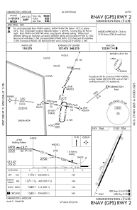
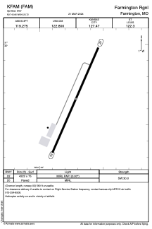


KFAM - Farmington Rgnl
Located in Farmington, United States
ICAO - FAM, IATA - FAM
Data provided by AirmateGeneral information
Coordinates: N37°45'39" W90°25'43"
Elevation is 945 feet MSL.
Magnetic variation is -02° East View others Airports in Missouri
Operational data
Special qualification required
Current time UTC:
Current local time:
Weather
METAR: KFAM 070814Z AUTO 16008KT 10SM BKN009 BKN050 21/20 A2966 RMK AO2 CIG 008V012
Communications frequencies: [VIEW]
Runways:
| RWY identifier | QFU | Length (ft) | Width (ft) | Surface | LDA (ft) |
| 02 | 24° | 4323 | 75 | CONC | |
| 20 | 204° | 4323 | 75 | CONC |
Airport contact information
Address: Farmington United States