


KEUG - Mahlon Sweet Fld
Located in Eugene, United States
ICAO - EUG, IATA - EUG
Data provided by AirmateGeneral information
Coordinates: N44°7'28" W123°12'43"
Elevation is 373 feet MSL.
Magnetic variation is 15° East View others Airports in Oregon
Operational data
Special qualification required
Current time UTC:
Current local time:
Weather
METAR: KEUG 022054Z 20010KT 10SM BKN050 15/06 A3006 RMK AO2 SLP177 T01500061 51008 $
TAF: KEUG 021738Z 0218/0318 19011KT P6SM FEW025 BKN100 FM030200 26006KT P6SM FEW025 BKN080 FM031000 18003KT 6SM BR FEW010 BKN060 FM031500 18006KT P6SM BKN050
Communications frequencies: [VIEW]
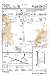
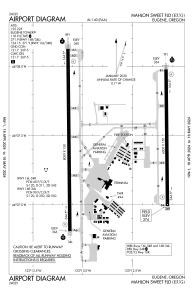
Runways:
| RWY identifier | QFU | Length (ft) | Width (ft) | Surface | LDA (ft) |
| 16L | 179° | 6000 | 150 | ASPH | 6000 |
| 34R | 359° | 6000 | 150 | ASPH | 6000 |
| 16R | 179° | 8009 | 150 | ASPH | 8009 |
| 34L | 359° | 8009 | 150 | ASPH | 8009 |
Airport contact information
Address: Eugene United States