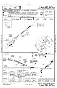
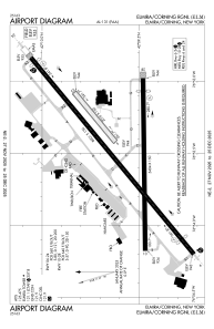


KELM - Elmira/Corning Rgnl
Located in Elmira/Corning, United States
ICAO - ELM, IATA - ELM
Data provided by AirmateGeneral information
Coordinates: N42°9'35" W76°53'30"
Elevation is 955 feet MSL.
Magnetic variation is -12° East View others Airports in New York
Operational data
Special qualification required
Current time UTC:
Current local time:
Weather
TAF: KELM 292334Z 3000/3024 VRB03KT P6SM BKN070 FM300400 VRB04KT P6SM VCSH BKN060 FM300800 00000KT 3SM BR SCT002 FM301300 19004KT P6SM SCT070 FM301800 23008KT P6SM -SHRA BKN025 TEMPO 3018/3020 4SM -TSRA BKN020CB FM302000 31009G14KT 3SM SHRA BR BKN012
Communications frequencies: [VIEW]
Runways:
| RWY identifier | QFU | Length (ft) | Width (ft) | Surface | LDA (ft) |
| 05 | 50° | 2016 | 150 | GRASS | 2017 |
| 23 | 230° | 2016 | 150 | GRASS | 2017 |
| 06 | 50° | 8001 | 150 | ASPH | 7401 |
| 24 | 230° | 8001 | 150 | ASPH | 7799 |
| 10 | 89° | 5404 | 150 | ASPH | 5004 |
| 28 | 269° | 5404 | 150 | ASPH | 5002 |
Airport contact information
Address: Elmira/Corning United States