


KEDW - Edwards Afb
Located in Edwards, United States
ICAO - EDW, IATA -
Data provided by AirmateGeneral information
Coordinates: N34°54'29" W117°53'8"
Elevation is 2311 feet MSL.
Magnetic variation is 12° East View others Airports in California
Operational data
Special qualification required
Current time UTC:
Current local time:
Weather
METAR: KEDW 032355Z 24015G26KT 50SM CLR 28/03 A2975 RMK AO2A PK WND 24027/52 SLP054 T02830032 10299 20249 56012
TAF: TAF KEDW 032100Z 0321/0503 VRB06KT 9999 SKC QNH2978INS BECMG 0321/0322 26012KT 9999 SKC QNH2976INS BECMG 0323/0324 27015G25KT 9999 SKC 510006 QNH2975INS BECMG 0403/0404 24010G15KT 9999 SKC QNH2979INS BECMG 0418/0419 24020G30KT 9999 SKC 510006 QNH2978INS BECMG 0420/0421 24025G40KT 9999 SCT200 520009 QNH2976INS TX29/0322Z TN13/0413Z
Communications frequencies: [VIEW]
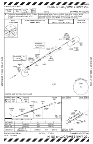
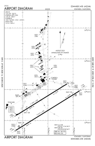
Runways:
| RWY identifier | QFU | Length (ft) | Width (ft) | Surface | LDA (ft) |
| 05L | 0° | 12000 | 200 | ASPH | |
| 23R | 0° | 12000 | 200 | ASPH | |
| 05R | 58° | 15024 | 300 | CONC | |
| 23L | 238° | 15024 | 300 | CONC | |
| 07 | 0° | 8000 | 50 | CONC | |
| 25 | 0° | 8000 | 50 | CONC |
Airport contact information
Address: Edwards United States
