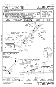
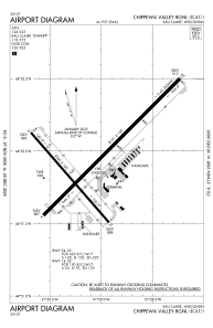


KEAU - Chippewa Valley Rgnl
Located in Eau Claire, United States
ICAO - EAU, IATA - EAU
Data provided by AirmateGeneral information
Coordinates: N44°51'57" W91°29'3"
Elevation is 913 feet MSL.
Magnetic variation is 01° East View others Airports in Wisconsin
Operational data
Special qualification required
Current time UTC:
Current local time:
Weather
METAR: KEAU 290156Z AUTO 08007KT 10SM OVC015 08/06 A2988 RMK AO2 RAE28 SLP122 P0001 T00780056 TSNO $
TAF: KEAU 282330Z 2900/2924 08012KT 6SM -RA BR OVC012 TEMPO 2900/2904 4SM -RA BR BKN008 FM290400 09009KT P6SM OVC007 FM291500 17008KT P6SM OVC005 FM291600 20009KT P6SM OVC006 FM292000 25012G20KT P6SM OVC009
Communications frequencies: [VIEW]
Runways:
| RWY identifier | QFU | Length (ft) | Width (ft) | Surface | LDA (ft) |
| 04 | 45° | 8101 | 150 | CONC | 7701 |
| 22 | 225° | 8101 | 150 | CONC | 7301 |
| 14 | 139° | 5000 | 100 | OTHER | 5000 |
| 32 | 319° | 5000 | 100 | OTHER | 5000 |
Airport contact information
Address: Eau Claire United States
