


KEAT - Pangborn Meml
Located in Wenatchee, United States
ICAO - EAT, IATA - EAT
Data provided by AirmateGeneral information
Coordinates: N47°23'56" W120°12'25"
Elevation is 1248 feet MSL.
Magnetic variation is 15° East View others Airports in Washington
Operational data
Special qualification required
Current time UTC:
Current local time:
Weather
METAR: KEAT 041555Z AUTO 25009KT 10SM -RA OVC055 11/06 A2963 RMK AO2 SLP032 P0001 T01060061
TAF: KEAT 041134Z 0412/0512 10004KT P6SM OVC100 FM041600 21007KT P6SM OVC060 TEMPO 0416/0420 -RA OVC030 FM042000 25011KT P6SM VCSH OVC050 FM050200 33009KT P6SM OVC050 PROB30 0502/0506 -RA FM050600 30011KT P6SM OVC060 TEMPO 0506/0510 -RA OVC030
Communications frequencies: [VIEW]
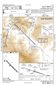
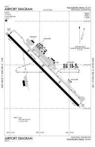
Runways:
| RWY identifier | QFU | Length (ft) | Width (ft) | Surface | LDA (ft) |
| 12 | 135° | 7000 | 150 | ASPH | 7000 |
| 30 | 315° | 7000 | 150 | ASPH | 7000 |
Airport contact information
Address: Wenatchee United States
