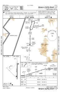
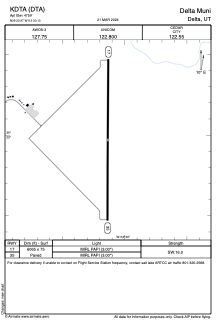


KDTA - Delta Muni
Located in Delta, United States
ICAO - DTA, IATA - DTA
Data provided by AirmateGeneral information
Coordinates: N39°22'58" W112°30'8"
Elevation is 4759 feet MSL.
Magnetic variation is 11° East View others Airports in Utah
Operational data
Special qualification required
Current time UTC:
Current local time:
Weather
METAR: KDTA 292315Z AUTO 21014G20KT 10SM BKN110 20/M01 A2980 RMK AO1
Communications frequencies: [VIEW]
Runways:
| RWY identifier | QFU | Length (ft) | Width (ft) | Surface | LDA (ft) |
| 17 | 180° | 6065 | 75 | ASPH | |
| 35 | 360° | 6065 | 75 | ASPH |
Airport contact information
Address: Delta United States