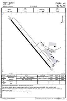


KDRT - Del Rio Intl
Located in Del Rio, United States
ICAO - DRT, IATA - DRT
Data provided by AirmateGeneral information
Coordinates: N29°22'27" W100°55'38"
Elevation is 1002 feet MSL.
Magnetic variation is 08° East View others Airports in Texas
Operational data
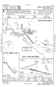
Special qualification required
Current time UTC:
Current local time:
Weather
METAR: KDRT 011653Z AUTO 12011KT 3SM -RA BKN014 OVC019 25/22 A2979 RMK AO2 RAB48 SLP077 P0000 T02500217 $
TAF: KDRT 011120Z 0112/0212 11007KT P6SM OVC020 FM011600 12012KT P6SM OVC025 FM011900 13013KT P6SM BKN035 FM012100 14014G24KT P6SM BKN045 PROB30 0121/0203 -TSRA BKN035CB FM020500 11012KT P6SM BKN018
Communications frequencies: [VIEW]
Runways:
| RWY identifier | QFU | Length (ft) | Width (ft) | Surface | LDA (ft) |
| 13 | 140° | 6300 | 100 | ASPH | 6000 |
| 31 | 320° | 6300 | 100 | ASPH | 5980 |
| H1 | 0° | 0 | 0 | UNK | |
| H2 | 0° | 0 | 0 | UNK |
Airport contact information
Address: Del Rio United States