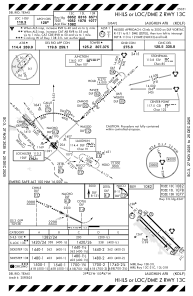
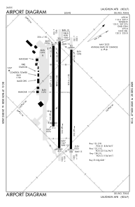


KDLF - Laughlin Afb
Located in Del Rio, United States
ICAO - DLF, IATA - DLF
Data provided by AirmateGeneral information
Coordinates: N29°21'34" W100°46'41"
Elevation is 1081 feet MSL.
Magnetic variation is 07° East View others Airports in Texas
Operational data
Special qualification required
Current time UTC:
Current local time:
Weather
METAR: KDLF 011455Z AUTO 11013KT 10SM OVC024 25/21 A2977 RMK AO2 CIG 023 RWY31 SLP068 T02510212 51007 $
TAF: TAF AMD KDLF 011325Z 0113/0217 13012G18KT 8000 -DZ BR BKN020 QNH2973INS TEMPO 0114/0116 6000 BR BKN015 BECMG 0116/0117 13012G18KT 9999 NSW BKN025 QNH2962INS BECMG 0119/0120 14012G20KT 9999 VCTS BKN040CB QNH2957INS TEMPO 0121/0203 VRB35G50KT -TSRAGR BKN045CB BECMG 0205/0206 12012KT 9999 NSW BKN012 QNH2960INS BECMG 0210/0211 12007KT 8000 BR BKN007 QNH2964INS WND VRB06KT AFT 0213 TEMPO 0212/0213 4800 -DZ OVC004 TX34/0122Z TN23/0211Z
Communications frequencies: [VIEW]
Runways:
| RWY identifier | QFU | Length (ft) | Width (ft) | Surface | LDA (ft) |
| 13C | 0° | 8852 | 150 | OTHER | |
| 31C | 0° | 8852 | 150 | OTHER | |
| 13L | 0° | 8316 | 150 | OTHER | |
| 31R | 0° | 8316 | 150 | OTHER | |
| 13R | 0° | 6571 | 150 | ASPH | |
| 31L | 0° | 6571 | 150 | ASPH |
Airport contact information
Address: Del Rio United States