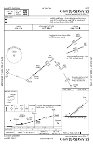
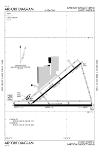


KDAG - Barstow-Daggett
Located in Daggett, United States
ICAO - DAG, IATA - DAG
Data provided by AirmateGeneral information
Coordinates: N34°51'13" W116°47'12"
Elevation is 1930 feet MSL.
Magnetic variation is 15° East View others Airports in California
Operational data
Special qualification required
Current time UTC:
Current local time:
Weather
METAR: KDAG 032050Z AUTO 26009G17KT 10SM CLR 29/01 A2978 RMK AO2 SLP061 T02890011 58021
TAF: KDAG 031720Z 0318/0418 30011G18KT P6SM SKC FM032100 19009KT P6SM SKC FM040100 25013G23KT P6SM SKC FM041600 25020G30KT P6SM SKC
Communications frequencies: [VIEW]
Runways:
| RWY identifier | QFU | Length (ft) | Width (ft) | Surface | LDA (ft) |
| 04 | 51° | 5123 | 100 | ASPH | |
| 22 | 231° | 5123 | 100 | ASPH | |
| 08 | 90° | 6402 | 150 | ASPH | |
| 26 | 270° | 6402 | 150 | ASPH |
Airport contact information
Address: Daggett United States