


KCWA - Central Wisconsin
Located in Mosinee, United States
ICAO - CWA, IATA - CWA
Data provided by AirmateGeneral information
Coordinates: N44°46'39" W89°40'0"
Elevation is 1277 feet MSL.
Magnetic variation is 00° East View others Airports in Wisconsin
Operational data
Special qualification required
Current time UTC:
Current local time:
Weather
METAR: KCWA 281847Z 07019KT 8SM -RA BKN010 OVC015 07/06 A2994
TAF: KCWA 281738Z 2818/2918 07012G21KT 6SM -SHRA BR OVC012 FM282100 07013G25KT 4SM SHRA BR OVC007 FM290100 08013G26KT 2SM -SHRA BR OVC005 WS020/12040KT FM290600 08011G19KT 2SM -SHRA BR OVC003 FM291500 14007KT 4SM -SHRA BKN006 FM291600 16007G16KT P6SM -SHRA BKN010
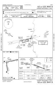
Communications frequencies: [VIEW]
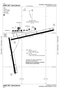
Runways:
| RWY identifier | QFU | Length (ft) | Width (ft) | Surface | LDA (ft) |
| 08 | 77° | 7648 | 150 | CONC | 7647 |
| 26 | 257° | 7648 | 150 | CONC | 7647 |
| 17 | 170° | 6501 | 150 | CONC | 6501 |
| 35 | 350° | 6501 | 150 | CONC | 6501 |
Airport contact information
Address: Mosinee United States
