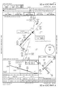
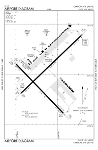


KCVS - Cannon Afb
Located in Clovis, United States
ICAO - CVS, IATA - CVS
Data provided by AirmateGeneral information
Coordinates: N34°22'58" W103°19'20"
Elevation is 4295 feet MSL.
Magnetic variation is 07° East View others Airports in New Mexico
Operational data
Special qualification required
Current time UTC:
Current local time:
Weather
METAR: KCVS 290555Z AUTO 00000KT 10SM CLR 13/00 A2993 RMK AO2 SLP097 T01320002 10223 20132 50010 PWINO FZRANO CHINO RWY22 $
TAF: TAF KCVS 290200Z 2902/3008 19012KT 9999 VCSH SCT080 BKN100 QNH2985INS TEMPO 2902/2904 24010G20KT 8000 -SHRA BECMG 2906/2907 VRB06KT 9999 NSW FEW080 SCT100 QNH2992INS BECMG 2914/2915 28010G15KT 9999 FEW120 QNH2998INS BECMG 2917/2918 25010G20KT 9999 SKC QNH2997INS BECMG 2921/2922 26015G25KT 9999 SKC QNH2985INS BECMG 2923/2924 23010G15KT 9999 SKC QNH2984INS BECMG 3001/3002 VRB06KT 9999 FEW150 QNH2987INS TX27/2922Z TN08/2912Z
Communications frequencies: [VIEW]
Runways:
| RWY identifier | QFU | Length (ft) | Width (ft) | Surface | LDA (ft) |
| 04 | 45° | 10003 | 150 | CONC | |
| 22 | 225° | 10003 | 150 | CONC | |
| 13 | 135° | 8196 | 150 | OTHER | |
| 31 | 315° | 8196 | 150 | OTHER |
Airport contact information
Address: Clovis United States