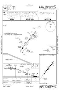
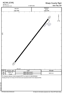


KCVK - Sharp County Rgnl
Located in Ash Flat, United States
ICAO - CVK, IATA -
Data provided by AirmateGeneral information
Coordinates: N36°15'54" W91°33'46"
Elevation is 717 feet MSL.
Magnetic variation is 02° East View others Airports in Arkansas
Operational data
Special qualification required
Current time UTC:
Current local time:
Weather at : KARG - Walnut Ridge Rgnl ( 59 km )
METAR: KARG 051156Z AUTO 01006KT 10SM CLR 18/18 A3001 RMK AO2 SLP161 T01780178 10194 20178 53010
Communications frequencies: [VIEW]
Runways:
| RWY identifier | QFU | Length (ft) | Width (ft) | Surface | LDA (ft) |
| 04 | 38° | 5158 | 75 | ASPH | |
| 22 | 218° | 5158 | 75 | ASPH |
Airport contact information
Address: Ash Flat United States