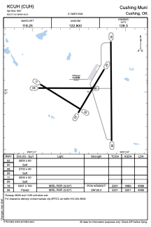


KCUH - Cushing Muni
Located in Cushing, United States
ICAO - CUH, IATA - CUH
Data provided by AirmateGeneral information
Coordinates: N35°57'0" W96°46'24"
Elevation is 925 feet MSL.
Magnetic variation is 05° East View others Airports in Oklahoma
Operational data
Special qualification required
Current time UTC:
Current local time:
Communications frequencies: [VIEW]
Runways:
| RWY identifier | QFU | Length (ft) | Width (ft) | Surface | LDA (ft) |
| 02 | 31° | 2650 | 60 | GRASS | |
| 20 | 211° | 2650 | 60 | GRASS | |
| 08 | 90° | 2700 | 40 | GRASS | |
| 26 | 270° | 2700 | 40 | GRASS | |
| 11 | 122° | 2500 | 50 | GRASS | |
| 29 | 302° | 2500 | 50 | GRASS | |
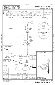
| 18 | 180° | 5201 | 100 | CONC | 4986 |
| 36 | 360° | 5201 | 100 | CONC | 4986 |
Airport contact information
Address: Cushing United States