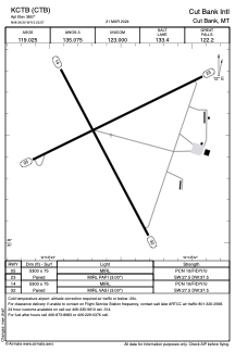


KCTB - Cut Bank Intl
Located in Cut Bank, United States
ICAO - CTB, IATA - CTB
Data provided by AirmateGeneral information
Coordinates: N48°36'30" W112°22'34"
Elevation is 3857 feet MSL.
Magnetic variation is 13° East View others Airports in Montana
Operational data
Special qualification required
Current time UTC:
Current local time:
Weather
METAR: KCTB 290956Z AUTO 23015KT 10SM CLR 05/M04 A2975 RMK AO2 SLP071 T00501039
TAF: KCTB 290520Z 2906/3006 24017G25KT P6SM SCT090 OVC250 FM291500 27020G30KT P6SM VCSH SCT090 BKN120 FM292300 27025G35KT P6SM VCSH SCT050 BKN090
Communications frequencies: [VIEW]
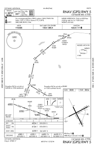
Runways:
| RWY identifier | QFU | Length (ft) | Width (ft) | Surface | LDA (ft) |
| 05 | 64° | 5300 | 75 | ASPH | |
| 23 | 244° | 5300 | 75 | ASPH | |
| 14 | 152° | 5300 | 75 | ASPH | |
| 32 | 332° | 5300 | 75 | ASPH |
Airport contact information
Address: Cut Bank United States
