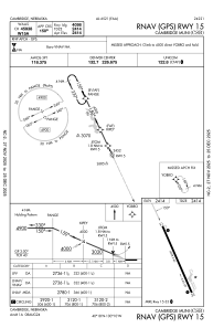
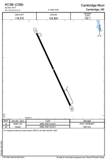


KCSB - Cambridge Muni
Located in Cambridge, United States
ICAO - CSB, IATA -
Data provided by AirmateGeneral information
Coordinates: N40°18'24" W100°9'43"
Elevation is 2414 feet MSL.
Magnetic variation is 05° East View others Airports in Nebraska
Operational data
Special qualification required
Current time UTC:
Current local time:
Weather at : KMCK - Mc Cook Ben Nelson Rgnl ( 38 km )
METAR: KMCK 291753Z AUTO 27009G17KT 10SM CLR 21/07 A2990 RMK AO2 SLP117 T02110072 10211 20022 58004
TAF: KMCK 291735Z 2918/3018 28011KT P6SM FEW120 FM300300 14011KT P6SM FEW250 FM301500 31015G25KT P6SM SCT250
Communications frequencies: [VIEW]
Runways:
| RWY identifier | QFU | Length (ft) | Width (ft) | Surface | LDA (ft) |
| 15 | 155° | 4098 | 60 | CONC | |
| 33 | 335° | 4098 | 60 | CONC |
Airport contact information
Address: Cambridge United States
