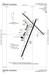


KCOU - Columbia Rgnl
Located in Columbia, United States
ICAO - COU, IATA - COU
Data provided by AirmateGeneral information
Coordinates: N38°49'4" W92°13'4"
Elevation is 889 feet MSL.
Magnetic variation is 00° East View others Airports in Missouri
Operational data
Special qualification required
Current time UTC:
Current local time:
Weather
METAR: KCOU 070554Z AUTO 15017G23KT 10SM BKN090 22/19 A2959 RMK AO2 SLP012 T02220189 10239 20211 402560144 58027
TAF: KCOU 070520Z 0706/0806 16014KT P6SM OVC050 FM070700 17014G24KT 5SM SHRA BR VCTS SCT015 OVC040CB TEMPO 0708/0710 VRB45KT 1SM +TSRA BKN015CB FM071000 18012G20KT P6SM VCSH OVC020 FM071400 21010G22KT P6SM BKN025 FM071700 24012G20KT P6SM SCT250
Communications frequencies: [VIEW]
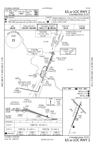
Runways:
| RWY identifier | QFU | Length (ft) | Width (ft) | Surface | LDA (ft) |
| 02 | 21° | 7401 | 150 | CONC | |
| 20 | 201° | 7401 | 150 | CONC | |
| 13 | 135° | 5500 | 100 | CONC | 5500 |
| 31 | 315° | 5500 | 100 | CONC | 5500 |
Airport contact information
Address: Columbia United States
