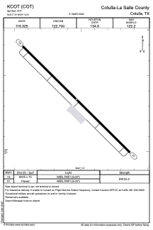


KCOT - Cotulla-La Salle County
Located in Cotulla, United States
ICAO - COT, IATA - COT
Data provided by AirmateGeneral information
Coordinates: N28°27'21" W99°13'2"
Elevation is 474 feet MSL.
Magnetic variation is 06° East View others Airports in Texas
Operational data
Special qualification required
Current time UTC:
Current local time:
Weather
METAR: KCOT 012153Z AUTO 08011KT 7SM BKN040 OVC048 29/23 A2965 RMK AO2 RAB06E16 SLP033 P0000 T02940228
TAF: KCOT 012207Z 0122/0218 11011KT P6SM VCTS OVC035CB TEMPO 0122/0202 3SM TSRA BKN020CB FM020500 13012KT P6SM BKN015 FM021400 14010KT P6SM OVC015
Communications frequencies: [VIEW]
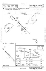
Runways:
| RWY identifier | QFU | Length (ft) | Width (ft) | Surface | LDA (ft) |
| 13 | 134° | 6005 | 75 | ASPH | |
| 31 | 314° | 6005 | 75 | ASPH |
Airport contact information
Address: Cotulla United States