


KCON - Concord Muni
Located in Concord, United States
ICAO - CON, IATA - CON
Data provided by AirmateGeneral information
Coordinates: N43°12'10" W71°30'8"
Elevation is 341 feet MSL.
Magnetic variation is -16° East View others Airports in New Hampshire
Operational data
Special qualification required
Current time UTC:
Current local time:
Weather
METAR: KCON 271251Z AUTO 00000KT 10SM CLR 08/M01 A3052 RMK AO2 SLP337 T00781011
TAF: KCON 271120Z 2712/2812 VRB03KT P6SM SKC FM271700 19007KT P6SM SKC FM280000 VRB03KT P6SM BKN250 FM280600 VRB03KT P6SM BKN050
Communications frequencies: [VIEW]
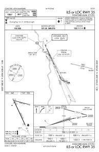
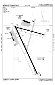
Runways:
| RWY identifier | QFU | Length (ft) | Width (ft) | Surface | LDA (ft) |
| 12 | 105° | 3200 | 75 | ASPH | |
| 30 | 285° | 3200 | 75 | ASPH | |
| 17 | 155° | 6005 | 100 | ASPH | |
| 35 | 335° | 6005 | 100 | ASPH |
Airport contact information
Address: Concord United States

