


KCMH - John Glenn Columbus Intl
Located in Columbus, United States
ICAO - CMH, IATA - CMH
Data provided by AirmateGeneral information
Coordinates: N39°59'49" W82°53'32"
Elevation is 815 feet MSL.
Magnetic variation is -07° East View others Airports in Ohio
Operational data
Special qualification required
Current time UTC:
Current local time:
Weather
METAR: KCMH 290251Z 17004KT 10SM CLR 22/14 A3003 RMK AO2 SLP163 T02220139 57002
TAF: KCMH 282327Z 2900/2924 20008KT P6SM SCT250 FM291400 21012G22KT P6SM SCT080 FM292000 21012G22KT P6SM BKN080
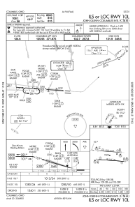
Communications frequencies: [VIEW]
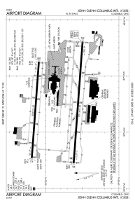
Runways:
| RWY identifier | QFU | Length (ft) | Width (ft) | Surface | LDA (ft) |
| 10R | 94° | 10114 | 150 | ASPH | 10113 |
| 28L | 274° | 10114 | 150 | ASPH | 10113 |
| 10L | 94° | 8000 | 150 | ASPH | 8000 |
| 28R | 274° | 8000 | 150 | ASPH | 8000 |
Airport contact information
Address: Columbus United States
