
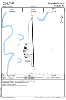


KCLS - Chehalis-Centralia
Located in Chehalis, United States
ICAO - CLS, IATA - CLS
Data provided by AirmateGeneral information
Coordinates: N46°40'37" W122°58'58"
Elevation is 177 feet MSL.
Magnetic variation is 16° East View others Airports in Washington
Operational data
Special qualification required
Current time UTC:
Current local time:
Weather
METAR: KCLS 040555Z AUTO 00000KT 5SM -RA FEW008 BKN011 OVC050 11/11 A2969 RMK AO2
Communications frequencies: [VIEW]
Runways:
| RWY identifier | QFU | Length (ft) | Width (ft) | Surface | LDA (ft) |
| 16 | 178° | 5000 | 140 | CONC | |
| 34 | 358° | 5000 | 140 | CONC |
Airport contact information
Address: Chehalis United States
