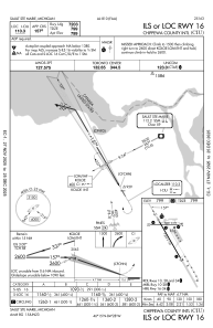
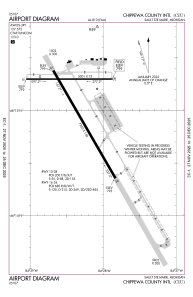


KCIU - Chippewa County Intl
Located in Sault Ste Marie, United States
ICAO - CIU, IATA - CIU
Data provided by AirmateGeneral information
Coordinates: N46°15'3" W84°28'21"
Elevation is 799 feet MSL.
Magnetic variation is -07° East View others Airports in Michigan
Operational data
Special qualification required
Current time UTC:
Current local time:
Weather
TAF: KCIU 041740Z 0418/0518 12010G17KT P6SM FEW250 FM050000 12009G15KT P6SM BKN025 FM050700 28006KT 4SM -SHRA BR OVC005 FM051300 31009G19KT P6SM SCT005
Communications frequencies: [VIEW]
Runways:
| RWY identifier | QFU | Length (ft) | Width (ft) | Surface | LDA (ft) |
| 10 | 90° | 5001 | 75 | ASPH | 5000 |
| 28 | 270° | 5001 | 75 | ASPH | 5000 |
| 16 | 150° | 7203 | 150 | OTHER | 7203 |
| 34 | 330° | 7203 | 150 | OTHER | 7203 |
Airport contact information
Address: Sault Ste Marie United States