


KBTM - Bert Mooney
Located in Butte, United States
ICAO - BTM, IATA - BTM
Data provided by AirmateGeneral information
Coordinates: N45°57'17" W112°29'51"
Elevation is 5550 feet MSL.
Magnetic variation is 12° East View others Airports in Montana
Operational data
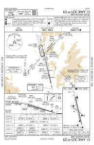
Special qualification required
Current time UTC:
Current local time:
Weather
METAR: KBTM 290953Z AUTO 20005KT 10SM FEW070 01/M03 A2989 RMK AO2 SLP113 T00111028
TAF: KBTM 290528Z 2906/3006 32008KT P6SM OVC100 FM291500 31008KT P6SM -SHRA OVC035 FM292200 29011G22KT P6SM -SHRA OVC050 FM300200 34013G26KT 2SM -SN OVC025 FM300400 30010KT P6SM VCSH OVC080
Communications frequencies: [VIEW]
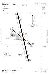
Runways:
| RWY identifier | QFU | Length (ft) | Width (ft) | Surface | LDA (ft) |
| 15 | 167° | 9000 | 150 | ASPH | 9000 |
| 33 | 347° | 9000 | 150 | ASPH | 9000 |
| 12 | 129° | 5100 | 75 | ASPH | 5100 |
| 30 | 309° | 5100 | 75 | ASPH | 5100 |
Airport contact information
Address: Butte United States