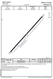


KBLF - Mercer County
Located in Bluefield, United States
ICAO - BLF, IATA - BLF
Data provided by AirmateGeneral information
Coordinates: N37°17'45" W81°12'27"
Elevation is 2856 feet MSL.
Magnetic variation is -07° East View others Airports in West Virginia
Operational data
Special qualification required
Current time UTC:
Current local time:
Weather
METAR: KBLF 290352Z AUTO 00000KT 10SM BKN055 19/11 A3020 RMK AO2 SLP195 T01890106
TAF: KBLF 282320Z 2900/2924 24010KT P6SM FEW070 FM290200 22003KT P6SM SKC FM291600 24010G20KT P6SM SCT080
Communications frequencies: [VIEW]
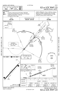
Runways:
| RWY identifier | QFU | Length (ft) | Width (ft) | Surface | LDA (ft) |
| 05 | 42° | 4743 | 100 | ASPH | 4743 |
| 23 | 222° | 4743 | 100 | ASPH | 4743 |
Airport contact information
Address: Bluefield United States
