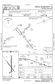
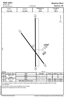


KBIE - Beatrice Muni
Located in Beatrice, United States
ICAO - BIE, IATA - BIE
Data provided by AirmateGeneral information
Coordinates: N40°18'5" W96°45'15"
Elevation is 1323 feet MSL.
Magnetic variation is 04° East View others Airports in Nebraska
Operational data
Special qualification required
Current time UTC:
Current local time:
Weather
METAR: KBIE 292235Z AUTO 30003KT 10SM SCT060 23/10 A2982 RMK AO2 T02280097
Communications frequencies: [VIEW]
Runways:
| RWY identifier | QFU | Length (ft) | Width (ft) | Surface | LDA (ft) |
| 14 | 143° | 4401 | 75 | CONC | |
| 32 | 323° | 4401 | 75 | CONC | |
| 18 | 180° | 5602 | 100 | CONC | 5602 |
| 36 | 360° | 5602 | 100 | CONC | 5602 |
Airport contact information
Address: Beatrice United States
