


KBGM - Greater Binghamton/Edwin A Link Fld
Located in Binghamton, United States
ICAO - BGM, IATA - BGM
Data provided by AirmateGeneral information
Coordinates: N42°12'30" W75°58'47"
Elevation is 1635 feet MSL.
Magnetic variation is -12° East View others Airports in New York
Operational data
Special qualification required
Current time UTC:
Current local time:
Weather
METAR: KBGM 300653Z AUTO 15007KT 10SM BKN110 18/13 A2988 RMK AO2 SLP109 T01780133
TAF: KBGM 300542Z 3006/0106 15008KT P6SM SCT080 SCT250 FM301100 14005KT P6SM BKN025 OVC040 FM301500 17007KT P6SM BKN045 FM301900 19010KT P6SM -SHRA BKN025 OVC040 TEMPO 3019/3021 3SM TSRA BKN018CB OVC035 FM302100 31009G14KT 5SM SHRA BR BKN009 OVC015 FM010200 34005KT 4SM BR OVC007
Communications frequencies: [VIEW]
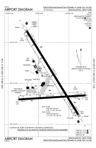
Runways:
| RWY identifier | QFU | Length (ft) | Width (ft) | Surface | LDA (ft) |
| 10 | 86° | 5001 | 150 | ASPH | 5001 |
| 28 | 266° | 5001 | 150 | ASPH | 5001 |
| 16 | 148° | 7305 | 150 | ASPH | 6905 |
| 34 | 328° | 7305 | 150 | ASPH | 7100 |
| H1 | 0° | 0 | 0 | UNK |
Airport contact information
Address: Binghamton United States
Other aviation service providers
Flight schools

Goodrich Pilot Training Center
Goodrich Pilot Training Center
doug@goodrichaviation.com+1(607)821-2982