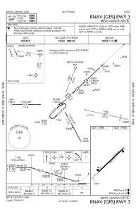
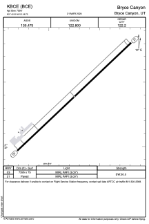


KBCE - Bryce Canyon
Located in Bryce Canyon, United States
ICAO - BCE, IATA - BCE
Data provided by AirmateGeneral information
Coordinates: N37°42'23" W112°8'45"
Elevation is 7590 feet MSL.
Magnetic variation is 14° East View others Airports in Utah
Operational data
Special qualification required
Current time UTC:
Current local time:
Weather
METAR: KBCE 291853Z AUTO 20007G18KT 10SM SCT075 14/M04 A3007 RMK AO2 SLP112 T01441039
TAF: KBCE 291720Z 2918/3018 VRB06KT P6SM SCT070 FM291900 23010KT P6SM SCT070 FM292000 23013G24KT P6SM SCT070 FM300300 27008KT P6SM SKC FM301600 23010KT P6SM SKC
Communications frequencies: [VIEW]
Runways:
| RWY identifier | QFU | Length (ft) | Width (ft) | Surface | LDA (ft) |
| 03 | 47° | 7395 | 75 | ASPH | |
| 21 | 227° | 7395 | 75 | ASPH |
Airport contact information
Address: Bryce Canyon United States