


KBBG - Branson
Located in Branson, United States
ICAO - BBG, IATA -
Data provided by AirmateGeneral information
Coordinates: N36°31'55" W93°12'2"
Elevation is 1302 feet MSL.
Magnetic variation is 02° East View others Airports in Missouri
Operational data
Special qualification required
Current time UTC:
Current local time:
Weather
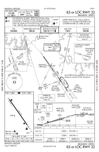
METAR: KBBG 070815Z AUTO 00000KT 3SM VCTS -RA 16/16 A2967 RMK AO2 P0017
TAF: KBBG 070742Z 0708/0806 30012G25KT 3SM TSRA BR OVC035CB WS020/20040KT FM070900 22009KT 6SM +SHRA BR VCTS OVC040CB WS020/22040KT FM071000 18010G18KT P6SM VCTS OVC030CB FM071100 19009KT P6SM BKN035 FM071700 24012KT P6SM SKC FM080400 20005KT P6SM SKC
Communications frequencies: [VIEW]
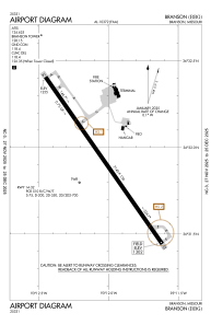
Runways:
| RWY identifier | QFU | Length (ft) | Width (ft) | Surface | LDA (ft) |
| 14 | 145° | 7140 | 150 | CONC | 7140 |
| 32 | 325° | 7140 | 150 | CONC | 7140 |
Airport contact information
Address: Branson United States